Newcastle Coal Mining Risk and Mining Subsidence at Bellway Homes, Bayfield Estate, West Allotment.
Geoinvestigate were asked by BBC’s Rip Off Britain to comment on the possible causes of the coal mining subsidence and recent building demolitions at West Allotment, Shiremoor. Subsidence and cracking of several homes was first noticed in 2015 and in 2016 families were moved out of several properties into temporary accommodation. The Bayfield Estate is a relatively new development and part of a larger development of several hundred houses by Bellway Homes on the east side of Newcastle.

- Initial drilling investigations at Nos 14 and 15
The Coal Authority have issued few press statements on the cause of the damage other than it is due to ‘historical coal mining subsidence’. The estate has been the focus of intense geotechnical and ground investigation by the Coal Authority over several months including drilling and monitoring.
Mining subsidence is so serious that 5 houses have been considered irreparable and have been demolished so far and a further 10 are earmarked for demolition. According to a source building subsidence problems and cracking initially affected House Nos 12, 14, 15, 16 and 17. The‘epicentre’ of the problem and the greatest movement seems to have been around House Nos 14 and 15 on Bayfield Road. Mining subsidence and the demolitions are broadly concentrated in the same area of the estate.

- Demolition of houses commences at No 12

Understandably local residents of the estate are worried whether their homes might be the next to have problems. They are also concerned about property blight and being unable to sell their houses with some already reporting difficulties. Residents have complained that they are not getting enough information from the Authorities on what has happened and why the problems weren’t picked up many years ago when the development was at the planning and investigation stage. The Chronicle Newspaper has been reporting on the problems at the estate as they have unfolded over many months and has raised concern about the reluctance of residents to talk to the press about the situation. While this is perhaps understandable because residents are concerned about the negative impact of publicity on house prices in the area it is creating difficulties getting an overall picture of the extent and nature of the problems. Others have accused the authorities of a lack of transparency.
Geoinvestigate have investigated the possible causes of the historical coal mining subsidence at the Bayfield Estate. Our findings are briefly summarised in the following drawing.

Geoinvestigate believes that the house demolitions may be due to the unexpected occurrence of very shallow or shallow coal mining subsidence in the area ringed in purple and white on the drawing. We believe that this coal mining hazard was missed or not fully appreciated during the original site investigation of the area in the early 2000s. Consequently the presence of shallow mine working wasn’t catered for in the design of the new buildings at the site and the new houses have been exposed to mining subsidence hazard.
The cost of putting right the problem and financial compensation is likely to run into many millions of pounds as each house is worth between 130K and 150K. The human cost has been significant with distressed families being asked to leave their homes and friends and move into temporary accommodation with an uncertain outcome. Neighbours fears about property blight and the difficulty of selling their homes even in areas of the estate currently unaffected by subsidence is understandable.
Geoinvestigate’s search uncovered that coal mining may have been carried out beneath the site in the late 1700s or early 1800s. Correspondence between James Clerk Maxwell (the world renowned Cambridge scientist) in the 1870s to his uncle Robert Dundas Cay who owned Prospect Hill Farm (the previous name of the land on which Bayfield Estate was built) together with notes from the Maxwell archive indicate that the family were in 1874 keenly alive to mining subsidence, claims and compensation. In fact reference is made to a claim for ‘surface damage’ at the farm after Robert Cay took possession of it in 1855. Surface damage was a term used by Victorians to describe subsidence of the ground surface caused by mining. Similarly surface damage is referred to many times in the archives of the Cleveland ironstone mines in the late 1800s and early 1900s in the context of the cracking, sagging or collapse of roads, farmland and houses arising from mining subsidence.


- James Clerk Maxwell. His contribution to science is considered as significant as Newtons or Einsteins
The ‘surface damage’ that Cay and Maxwell discussed may include the circular mound or depression which can be clearly seen a little to the north of the Prospect Hill farm buildings on the OS map of 1861. While this feature might be a pond it could also be a large sinkhole collapse or a pond formed in a depression where the ground has sunk or foundered because of mining subsidence below it. This feature is about 10m in diameter and as the current street plan shows is close to the ‘epicentre’ of the subsidence problem at the Bayfield Estate and Nos 14 and 15 these being the first demolitions. It is possible therefore that House Nos 12, 14, 15 and 16 were built over or close to ground which had already collapsed or was highly unstable and likely to experience further subsidence especially if the weight of new buildings were added to it.

- 1861 map feature. Possibly a mine shaft or sinkhole caused by ground subsidence or collapse.
Other explanations for the circular feature are that it is a bell pit indicating shallower working or a deeper mine shaft. In the early 2000s this feature should have been identified as being of concern following a routine map search as part of routine pre-construction site investigation by a competent engineering geologist or mining specialist.
The 1975 geological map shows the outcrop of a coal seam lying to the south of Prospect Hill Farm and the Bayfield Estate. However the position of this outcrop is uncertain and as such is flagged as a warning with a dashed rather than a solid black line. If the position of this coal seam was wrong (not an untypical situation) and it lay further north beneath Prospect Hill Farm and therefore below the future Bayfield Estate underground coal mine workings could occur at very shallow depth beneath the housing estate with very serious impact on ground stability in this area.
The presence of an ‘old sandstone quarry’ to the east of the site in 1861 and a rise in bedrock level at this location and along the Prospect Hill ridge including the Bayfield Estate could also cause the coal seam to extend further north than shown on the geological map.
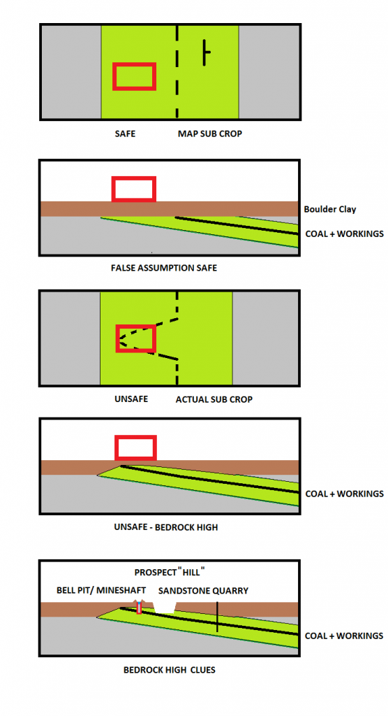
- A local bedrock high at ‘Prospect Hill’ could cause the coal seam to extend further north.

Therefore in the early 2000s it would have been important to confirm that the geological map was correct and that this coal seam and any mine workings within it did not extend further north and under the housing development. This should have been carried out as part of the pre-construction planning investigations after all the development is located in a part of Newcastle where historical coal mining was known to be extensive and there were other mine shafts in the vicinity such as John (Coal) Pit shown on the plan to the east of the Bayfield Estate development.

While the presence of an old sandstone quarry near to the site is not in itself unduly alarming closer inspection of the 1861 map shows a dashed pathway within the quarry leading eastwards possibly into a mine adit or horizontal mine tunnel. This tunnel might perhaps run under the future Bayfield Housing Estate and connect with the circular 1861 map feature shown in this area. This mine entry may lead to underground sandstone mine workings or workings in a coal seam which might have been encountered in the walls of the quarry during its excavation. The possible occurrence of a horizontal adit extension from this quarry under the housing estate would have been of concern to Geoinvestigate in the early 2000s and in our opinion would have warranted investigation at this time.

- Pathway leads to a dead end at a cliff face or an adit into the quarry side and then further east?
Perhaps of most surprise is a 1788 borehole log which turned up during our serach. The log of Boring No 1806 is presented below. Unfortunately the exact location of the borehole is unknown though it is our opinion that it is probably located on the south side of Prospect Hill because the borehole encountered ‘whin’ placing it in the vicinity of the Tynemouth Dyke which only occurs south of Prospect Hill. In addition the farm would have been a recognisable landmark at this earlier time with Prospecthill railway station only being established after 1845.

The reference on the log to ‘Box and old borehole’ is interesting because it suggests that the borehole was an earlier borehole which had been re-drilled or re-bored and deepened several years later in 1788. Box has several meanings in the lexicon of early mining terms including fine debris at the bottom of a mine cart – the latter also known as a Box or cart. Therefore Box may refer to the fine debris which had subsequently fallen into the borehole after it was abandoned. Re-drilling of the borehole would also explain the unusual absence of a description on the log of the ground above the ‘box and old borehole’ whereas a full rock description is given below it in the newer section of borehole.
In 1788 Boring No 1806 encountered a 1m thick unnamed coal seam at a depth of 23m. This coal seam would rise at 3 to 6 degrees with the strata northward towards Prospect Hill Farm and consequently towards Bellway Home’s future Bayfield Housing Estate. Therefore at the Bayfield Estate coal seam and mine workings could lie at shallow or very shallow depth approaching surface or outcrop a short distance to the north of the estate as suggested on the drawing.
While this borehole and the correspondence between James Maxwell and Robert Cay is less likely to have been found as part of a routine search in early 2000 there were other obvious warnings that the site may be at risk from coal mining legacy that should have been heeded.
Bearing in mind the changes which have occurred in recent years with the introduction of more rigorous Coal Mining Risk Assessment or CMRA in 2011 and the more stringent scrutiny of coal mining legacy and its impact on new development by consultants and the Coal Authority which has followed, the BBC asked Geoinvestigate what were the warnings in the early 2000s that there might be mining problems at West Allotment.
Without the benefit of hindsight Geoinvestigate’s response to the BBC was that there were 3 obvious warnings requiring further investigation in the early 2000s namely –
The uncertain position of the coal outcrop shown on the 1975 geological map to the south of the site. If this outcrop extended northwards mine workings could also extend under the Bayfield housing estate and lie at shallow or very shallow depth where they would pose a serious risk of mining subsidence to new buildings.
The presence of a circular 1861 map feature within the housing estate – possibly indicative of a mining sinkhole, collapsed or subsided ground or a very shallow bell pit or a deeper mine shaft. This feature alone would have necessitated careful investigation.
A possible mine adit extending horizontally out from an old sandstone quarry and under the site perhaps linking with the circular 1861 map feature or mine shaft shown to the east of the quarry.
Geoinvestigate told the BBCs interviewer that had these warnings been thoroughly investigated it’s difficult to see how a competent mining or geological consultant would not have identified the shallow coal mine hazard beneath the Bayfield Estate. Had these problems been identified at the beginning steps could have been taken then to make the ground safe including stabilising it by filling the workings with cement and supporting new buildings on specially strengthened foundations. Alternatively building could have been avoided altogether in the area currently subject to 15 house demolitions although this would have been an extreme measure.
Our response to the BBC’s question about who was responsible for the problems at the Bayfield Estate and for picking up the cost was – “We are sure that the lawyers on both sides are busy at the moment arguing that. However there were clear warnings and we need to find out what happened and why those warning don’t appear to have been recognised in this instance”.
The BBCs final question – “Could it happen again”?
Probably not with the advent of more rigorous Coal Mining Risk Assessment or CMRA and the resulting increased scrutiny and management of mining risk in recent years. The positive outcome from the coal mining subsidence problems at West Allotment may be that when the dust has settled and the details and failings become clear it will help to highlight past deficiencies in mining risk assessment. Bayfield Estate may also increase public awareness of the hazards from coal mining legacy and make builders and developers less reluctant to spend money on exploratory drilling which still remains the only conclusive way of confirming whether a site is underlain by mine workings or not.

- Possible interpretation of historical mining subsidence at Bellway Homes, Bayfield Estate, West Allotment, Newcastle
The same applies not only to the investigation of coal mining legacy but also building development over historical Chalk workings in the South of England and the well publicised problem of natural Gypsum sinkholes and building subsidence in the Ripon area – the latter having recently been described as the Sinkhole Capital of Britain. Put quite simply more drilling investigation is needed to develop these areas safely and to avoid more problems like Bayfield Estate in the future.
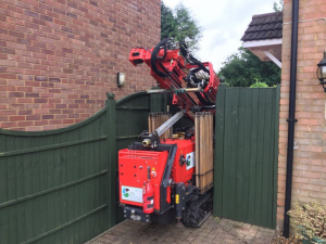
- Microdrill on its way into a back garden to drill holes to locate mine workings

With the recent introduction into the UK of safe, high speed, compact, site friendly and cost effective microdrilling borehole technology there is now no excuse not to drill in gardens, in small restricted spaces and below houses and buildings where mine workings or mine shaft hazards are suspected. Only by drilling can the presence, nature and the cost of putting these defects right be confirmed.